

When considering travel in the United States, iconic landmarks like the Grand Canyon, Statue of Liberty, or Yellowstone National Park often come to mind. Yet, hidden within the vast landscapes of this diverse country are hidden travel spots in the USA—incredible, lesser-known destinations waiting to be discovered. These spots offer tranquility, unique experiences, and unforgettable memories away from the crowds. Let’s dive into some of the rare gems of the USA, perfect for your next adventure.
1. Great Basin National Park: Nevada


Why it’s meaningful to you
What makes Great Basin National Park stand out is its incredible diversity, from ancient bristlecone pines to the majestic peaks of Wheeler Mountain. The park’s dark skies provide unmatched stargazing opportunities, while Lehman Caves offer a glimpse into a fascinating underground world. Its serene atmosphere and breathtaking landscapes make it a true hidden gem for nature lovers.
Great Basin National Park, located in eastern Nevada near the Utah border, is a hidden gem known for its stunning natural beauty and remote landscapes. Spanning over around 77,000 acres, this peaceful park offers rugged mountains, ancient forests, and star-filled skies, making it a perfect destination for outdoor enthusiasts and those seeking solitude in nature.
| Feature | Details |
|---|---|
| Location | White Pine County, Nevada, United States |
| Coordinates | 39.00581°N 114.21969°W |
| Area | 77,180 acres (312.3 km²) |
| Established | October 27, 1986 |
Source: Wikipedia
Great Basin National Park, nestled in the heart of eastern Nevada, is an offbeat treasure that offers a blend of striking landscapes, starry skies, and serene solitude. This hidden gem is home to ancient bristlecone pines, the towering Wheeler Peak, and the fascinating Lehman Caves, making it a must-visit destination for adventurers and nature enthusiasts. With its rugged beauty and diverse ecosystems, the park provides a peaceful escape from the hustle and bustle of everyday life.
Visitors can explore the park year-round, with each season offering a unique experience. In summer, enjoy hiking the scenic trails leading to alpine lakes and glacier-carved peaks. Winter transforms the park into a snowy wonderland perfect for snowshoeing and stargazing, as Great Basin is designated as an International Dark Sky Park. The park also boasts one of the clearest night skies in the country, offering unparalleled views of the Milky Way and beyond.
Whether you marvel at the intricate formations in Lehman Caves, stand in awe of the 5,000-year-old bristlecone pines, or soak in the panoramic views from Wheeler Peak, Great Basin National Park delivers unforgettable moments. Its tranquil setting and unspoiled beauty make it the perfect destination for those seeking a quieter yet equally breathtaking outdoor adventure.
Best Activities for Great Basin National Park
- Hiking: Explore the park’s scenic trails, from the easy Wheeler Peak Trail to the more challenging routes leading to alpine lakes and stunning vistas. Don’t miss the iconic Bristlecone Pine Trail, home to some of the world’s oldest trees.
- Stargazing: As one of the darkest places in the U.S., Great Basin National Park offers incredible stargazing opportunities, with clear night skies perfect for viewing the Milky Way, planets, and meteor showers.
- Caving: Explore the Lehman Caves, a stunning limestone cave system with intricate formations such as stalactites, stalagmites, and cave shields. Guided tours are available to navigate this underground wonder.
- Camping: Enjoy camping under the stars at one of the park’s campgrounds or backcountry sites, surrounded by the natural beauty and tranquility of the Great Basin.
- Wildlife Watching: Spot diverse wildlife, including mule deer, bighorn sheep, and a variety of bird species, as you explore the park’s unique habitats, ranging from desert valleys to alpine meadows.
- Scenic Drives: Drive along the Wheeler Peak Scenic Drive for panoramic views of the park’s rugged mountains, wildflower-filled meadows, and expansive valleys.
- Fishing: Fish in the park’s pristine alpine lakes and streams, offering peaceful spots for trout fishing amidst a serene wilderness setting.
- Photography: Capture the dramatic landscapes, from towering peaks to the ancient Bristlecone Pines, and the unique desert flora and fauna. Sunrise and sunset offer especially striking light.
- Backpacking: For experienced hikers, embark on a multi-day backpacking adventure to explore the more remote areas of the park, offering solitude and stunning vistas.
- Winter Sports: In the winter, enjoy snowshoeing and cross-country skiing on the park’s trails, with the chance to explore the snowy landscape away from the crowds.
Best Time to Visit:
The best time to visit Great Basin National Park is from late spring to early fall (May to October). This period offers pleasant weather for hiking and exploring, with wildflowers blooming in the meadows and snow-free access to trails. Stargazing is exceptional year-round, but summer and early fall nights are particularly clear.
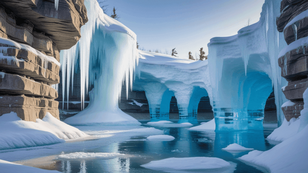
2. Apostle Islands Ice Caves: Wisconsin
Why It’s Special for You
The Apostle Islands Ice Caves offer a mesmerizing winter escape, where frozen waterfalls and shimmering ice formations turn the shoreline into a natural masterpiece. Nestled along Lake Superior, this seasonal wonder provides a one-of-a-kind adventure for nature enthusiasts and photographers. It’s a true gem that captures the magic of winter like no other.
Apostle Islands Ice Caves, nestled along the shores of Lake Superior in northern Wisconsin, are a breathtaking natural wonder that transforms with the seasons. During winter, these caves become a frozen paradise, adorned with intricate icicles and crystalline formations that draw visitors into a magical, icy realm. Accessible by foot when the lake freezes over, these unique caves offer a serene escape for adventurers and photographers, making them an unforgettable destination for anyone seeking nature’s wintry artistry.
| Features | Details |
|---|---|
| Location | Apostle Islands, Wisconsin, USA |
| Coordinates | 46°57′55″N, 90°39′51″W |
| Area | 19,000 acres (76.9 km²) |
| Annual Visitors | Varies (hundreds of thousands in peak winter months) |
| Established | 1970 (designated part of Apostle Islands National Lakeshore) |
Source: Wikipedia
The Apostle Islands Ice Caves, located along the shores of Lake Superior in northern Wisconsin, offer a breathtaking winter experience for visitors. This unique natural wonder features stunning ice formations, frozen waterfalls, and crystal-clear ice tunnels that attract adventurers and nature lovers alike. Accessible only during the winter months when conditions are right, the ice caves are a rare and awe-inspiring sight. The area is part of the Apostle Islands National Lakeshore, which includes miles of pristine shoreline, ancient forests, and diverse wildlife, making it a year-round destination for outdoor enthusiasts.
The ice caves are open to visitors when the ice on Lake Superior is thick enough to safely walk across, typically from late January to early March. It’s important to check the conditions before planning a visit, as the ice needs to be strong enough for safety. Entrance to the caves is free, providing an affordable way to explore this natural wonder. The scenic journey to the caves is also part of the experience, as visitors can hike along the frozen shoreline or take a guided tour to learn more about the history and geology of the region.
Whether you’re walking through the sparkling ice tunnels, photographing the majestic ice formations, or simply enjoying the serene winter landscape, the Apostle Islands Ice Caves offer an unforgettable adventure. With its tranquil environment and dramatic beauty, it’s the perfect place for anyone seeking an extraordinary winter escape.
Activities to Explore
- Winter Hikes:Traverse the frozen shoreline of Lake Superior to reach the ice caves. This magical journey allows you to walk on glistening ice, surrounded by towering icicles and crystalline formations.
- Snowshoeing: Strap on snowshoes and explore the rugged terrain, accessing more remote caves and enjoying the serene beauty of the winter landscape.
- Ice Climbing: For the adventurous, climb the frozen cliffs and waterfalls surrounding the caves. Guided experiences make it accessible for both beginners and seasoned climbers.
- Photography:Frame the breathtaking ice sculptures and dramatic frozen landscapes. Sunrise and sunset offer particularly stunning lighting for unique photos.
- Kayaking: Visit in the summer to paddle through the open sea caves, exploring their intricate passageways and resonant chambers.
- Camping: Extend your adventure by camping in nearby parks or along the Lake Superior shoreline, immersing yourself in the tranquility of nature year-round.
- Cultural Exploration: Learn about the history and geology of the Apostle Islands and the indigenous communities that have called this area home for centuries.
Best Time to Visit:
The best time to visit the Apostle Islands Ice Caves is typically from January to March when Lake Superior freezes over and the caves become accessible. Always check ice conditions and safety updates before planning your trip.
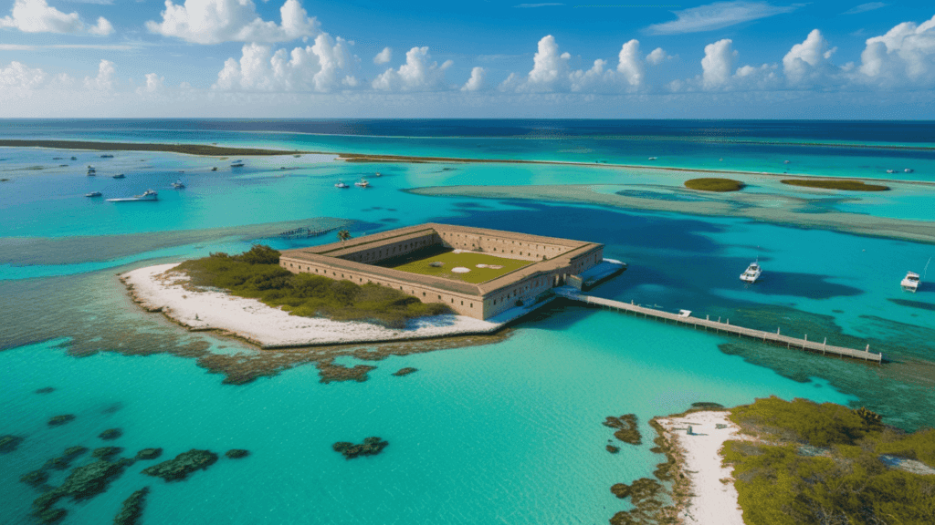
3.Dry Tortugas National Park: Florida
Why It’s Special
Dry Tortugas National Park is a captivating blend of history and natural splendor. Encircled by clear turquoise waters and vibrant coral reefs, it offers a tranquil retreat unlike any other. Highlighted by the historic Fort Jefferson, the park is an ideal spot for snorkeling, diving, and enjoying the calm of a remote island paradise.
Dry Tortugas National Park is located in North America, within the United States, in the state of Florida. It lies approximately 70 miles west of Key West in the Gulf of Mexico. This remote park spans a cluster of seven small islands, known as the Dry Tortugas, and is surrounded by stunning turquoise waters and vibrant coral reefs.
| Features | Details |
|---|---|
| Location | Monroe County, Florida, United States |
| Coordinates | 24°37′43″N 82°52′24″W |
| Area | 64,701 acres (261.84 km²) |
| Annual Visitors | 56,810 (in 2018) |
| Established | January 4, 1935 |
Source: Wikipedia
Dry Tortugas National Park, located about 70 miles west of Key West, Florida, is a tropical paradise known for its crystal-clear waters, vibrant coral reefs, and rich history. This remote park, accessible only by boat or seaplane, offers visitors an opportunity to explore the stunning natural beauty of the Florida Keys, as well as the historic Fort Jefferson, a 19th-century military outpost. The park covers over 100 square miles, with most of it being submerged, making it a prime spot for snorkeling, scuba diving, and birdwatching.
The park is open year-round, with the best time to visit being during the cooler months from December to April. However, due to its remote location, it’s essential to plan your visit in advance, especially if you’re taking a boat or plane trip. There is an entrance fee to the park, but it’s well worth the cost for the chance to experience the unspoiled beauty and tranquility of the area. Camping is available on Garden Key, where visitors can spend the night under the stars and wake up to the sound of waves lapping against the shore.
Whether you’re exploring the historic fort, snorkeling in the vibrant waters, or simply soaking in the peaceful surroundings, Dry Tortugas National Park offers a unique and unforgettable experience. With its stunning landscapes, rich history, and diverse wildlife, it’s a perfect destination for those seeking adventure, relaxation, and a deeper connection with nature.
Top Activities for Dry Tortugas National Park
- Snorkeling: The park’s vibrant coral reefs and underwater ecosystems are famous, making snorkeling one of its primary attractions.
- Touring Fort Jefferson: Fort Jefferson, a massive 19th-century coastal fortress, is the centerpiece of the park and a must-see for visitors interested in history.
- Camping: Dry Tortugas is one of the most remote camping spots in the U.S., offering unparalleled stargazing due to its isolation.
- Kayaking: Paddling around the islands is a popular way to explore the shallow waters, see wildlife, and access less-visited areas.
- Bird Watching: The park is part of a major migratory bird route, and rare species frequently stop at the islands.
- Fishing: Fishing is allowed in designated areas around Dry Tortugas and is a common activity for visitors.
- Swimming and Beachcombing: The park’s beaches are pristine and ideal for relaxation and exploration.
- Underwater Photography: The clear waters and marine diversity make this a favorite destination for underwater photography.
- Exploring Garden Key: Garden Key houses Fort Jefferson and is the main area visitors explore when they arrive.
- Scuba Diving: While less common than snorkeling, scuba diving around the park offers access to deeper reefs and shipwrecks.
Best Time to Visit:
The best time to visit Dry Tortugas National Park is from late fall to early spring (November to April) when the weather is mild and hurricane risks are low. This period offers ideal conditions for snorkeling, camping, and exploring Fort Jefferson.
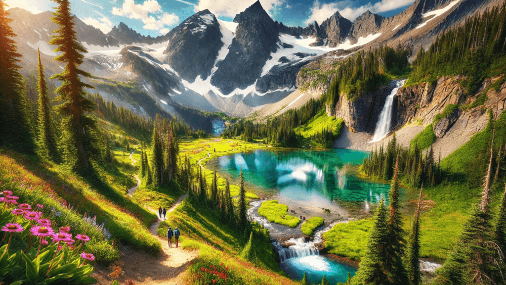
4.North Cascades National Park: Washington
What you love most about it
North Cascades National Park is a stunning haven of rugged peaks, crystal-clear lakes, and lush forests. Known for its untouched wilderness, it’s perfect for hiking, climbing, and reconnecting with nature. With breathtaking views at every turn, this park offers a serene escape into the heart of the wild.
North Cascades National Park, located in northern Washington near the Canadian border, is a pristine wilderness renowned for its rugged beauty and awe-inspiring landscapes. Encompassing jagged peaks, lush forests, and turquoise alpine lakes, this park is a haven for hikers, climbers, and nature lovers. Often called the “American Alps,” it offers unparalleled opportunities for adventure and solitude, making it a must-visit destination for those seeking a connection with the untamed beauty of the Pacific Northwest.
| Feature | Details |
|---|---|
| Location | Whatcom, Skagit, and Chelan counties, Washington, U.S. |
| Nearest City | Sedro-Woolley, Washington |
| Coordinates | 48°49′58″N 121°20′51″W |
| Area | 504,654 acres (2,042.26 km²) |
| Established | October 2, 1968 |
| Visitors | 30,154 (in 2022) |
Source: Wikipedia
North Cascades National Park, located in northern Washington, is a beautiful and remote park known for its stunning mountains, alpine lakes, and diverse wildlife. Covering over 500,000 acres, it’s a perfect spot for outdoor activities like hiking, camping, and fishing. The park features towering peaks, glaciers, and dense forests, making it a must-visit for nature lovers.
The park is open throughout the year, but the best time to visit is in the summer and fall when the weather is ideal for outdoor adventures. There’s no entrance fee, but certain areas may require permits for camping or other activities. The park is also great for stargazing, thanks to its clear skies and minimal light pollution.
Whether you’re hiking to scenic viewpoints, camping in the backcountry, or simply enjoying the peaceful surroundings, North Cascades National Park offers a chance to connect with nature. Its breathtaking landscapes and quiet atmosphere make it an excellent choice for anyone seeking adventure and serenity
Family-friendly activities at North Cascades
- Hiking:Explore a variety of trails, from easy walks to challenging backcountry hikes, offering breathtaking views of glaciers, alpine lakes, and rugged peaks. Popular hikes include Cascade Pass and Maple Pass.
- Wildlife Watching:Spot diverse wildlife, such as black bears, mountain goats, elk, and a variety of bird species, as you traverse the park’s diverse ecosystems.
- Camping:Experience the tranquility of the park by camping in one of its backcountry or front-country campgrounds, surrounded by the natural beauty of the North Cascades.
- Scenic Drives: Take a drive along the North Cascades Scenic Highway (State Route 20) for panoramic views of towering mountains, cascading waterfalls, and lush valleys.
- Kayaking and Canoeing:Paddle in one of the park’s serene alpine lakes, such as Diablo Lake or Ross Lake, surrounded by towering peaks and dense forests.
- Photography:Capture stunning views of glaciers, alpine meadows, and cascading waterfalls, especially during the summer months when wildflowers are in bloom.
- Backpacking:For experienced adventurers, embark on a multi-day backpacking trip to explore the more remote areas of the park, offering solitude and incredible vistas.
- Fishing:Enjoy fishing in the park’s pristine rivers and lakes, with opportunities to catch species like rainbow trout and kokanee salmon.
- Climbing:North Cascades is renowned for its challenging climbing routes, attracting mountaineers from around the world to tackle its peaks and glaciers.
- Winter Sports: In the colder months, enjoy snowshoeing, cross-country skiing, and even downhill skiing at nearby resorts, taking advantage of the park’s snowy wonderland.
Best Time to Visit:
The best time to visit North Cascades National Park is from mid-July to early September, when snow-free trails and pleasant weather make hiking, camping, and exploring the rugged mountain scenery most accessible. During this period, the park’s alpine meadows bloom with wildflowers, and glacial lakes sparkle under clear skies.
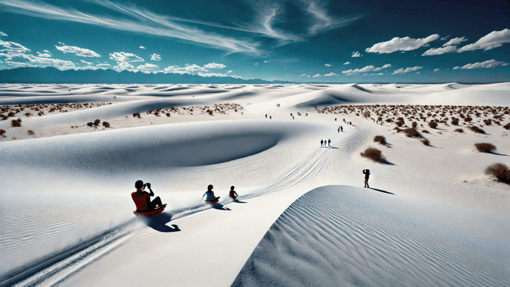
5.White Sands National Park: New Mexico
What makes it unique for you
White Sands National Park is special because of its endless white gypsum dunes that look like another world. You can hike, sled, or just enjoy the bright white sand against the blue sky. It’s a perfect and unforgettable place for every visitor.
White Sands National Park, located in southern New Mexico, is a mesmerizing expanse of glistening white gypsum dunes that stretches across 275 square miles. This otherworldly landscape, the largest of its kind on Earth, captivates visitors with its rolling sand dunes, striking sunsets, and serene atmosphere. Perfect for hiking, sledding, and stargazing, White Sands offers a unique escape into nature’s artistry, where every step feels like a journey through a dreamlike desert wonderland.
| Feature | Details |
|---|---|
| Location | Otero County and Doña Ana County, New Mexico, United States |
| Nearest City | Alamogordo, New Mexico |
| Coordinates | 32°46′45″N 106°10′19″W |
| Area | 145,762 acres (227.753 sq mi; 589.88 km²) |
| Established | January 18, 1933 (as a national monument), December 20, 2019 (as a national park) |
| Visitors | 729,096 (in 2023) |
Source: Wikipedia
White Sands National Park, located in southern New Mexico, is a unique and breathtaking destination known for its vast, stunning white sand dunes. Spanning over 275 square miles, the park is home to the largest gypsum sand dune field in the world. The sparkling white dunes create an otherworldly landscape that attracts visitors from around the globe, offering opportunities for activities like hiking, photography, and even sledding down the dunes.
The park is open year-round, with the best time to visit being in the spring or fall when temperatures are cooler. There is an entrance fee, but the chance to explore this incredible natural wonder is well worth it. Visitors can enjoy several scenic drives, along with a variety of hiking trails that lead to panoramic views of the surrounding desert. The park is also a great spot for stargazing, with clear night skies and minimal light pollution.
Whether you’re hiking through the soft dunes, watching a desert sunset, or simply marveling at the beauty of the landscape, White Sands National Park offers a peaceful and unforgettable experience. Its unique environment and tranquil atmosphere make it a perfect destination for nature lovers and those seeking adventure in a one-of-a-kind setting.
Activities for this place
- Dune Sledding:Glide down the soft, gypsum sand dunes on a sled for a thrilling and unique experience that’s fun for all ages.
- Hiking:Explore the park’s beauty through trails like the Alkali Flat Trail or the Dune Life Nature Trail, each offering unique perspectives on the desert landscape.
- Photography:Capture the dramatic contrast of the white dunes against the blue sky, particularly during sunrise and sunset when the light transforms the scenery.
- Stargazing:Experience one of the darkest skies in the U.S., perfect for stargazing and astrophotography during clear nights.
- Wildlife Watching: Spot unique desert wildlife, including lizards, birds, and nocturnal creatures like foxes and rodents.
- Picnicking:Enjoy a serene meal at one of the designated picnic areas surrounded by the stunning white sand.
- Guided Ranger Programs: Join a ranger-led walk or talk to learn about the park’s fascinating geology, history, and unique ecosystem.
- Biking:Cycle along the Dunes Drive, an 8-mile loop that winds through the heart of the white sand landscape.
- Camping: Stay overnight at one of the park’s backcountry camping spots to fully immerse yourself in the desert’s tranquility.
- Educational Discovery:Visit the park’s visitor center to learn about the formation of the gypsum dunes and the area’s cultural history.
Best Time to Visit:
The best time to visit White Sands National Park is from October to April, when cooler temperatures make exploring the gypsum sand dunes more comfortable. Early mornings and evenings offer stunning views and softer light, perfect for photography and leisurely walks.
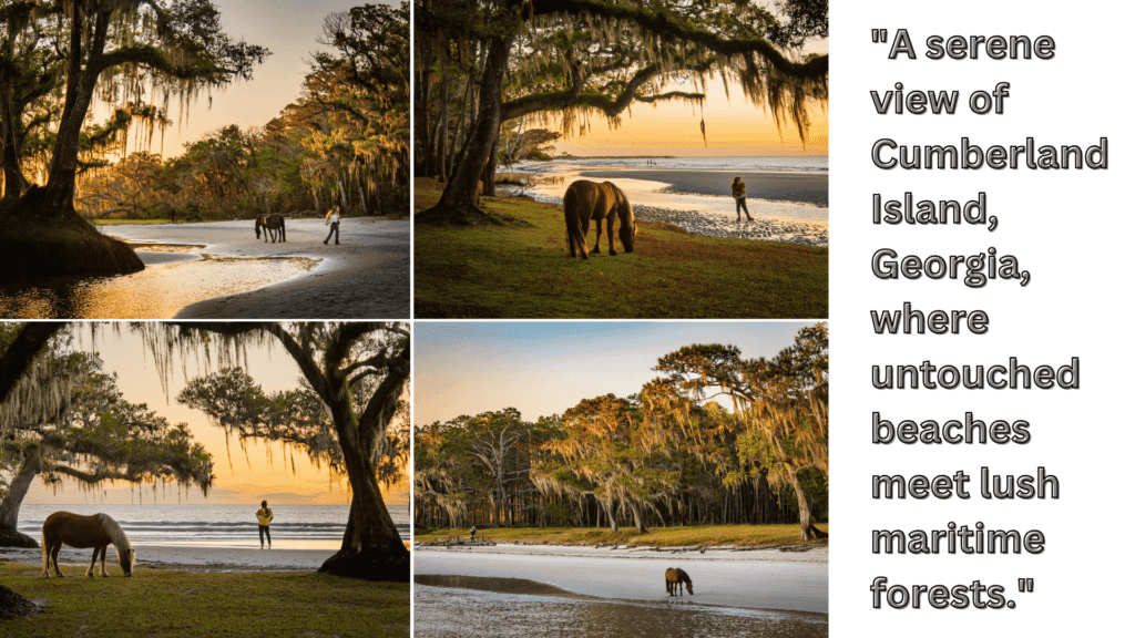
6.Cumberland Island: Lesser-known treasure in Georgia
Why its special for you!
Cumberland Island, Georgia, is a captivating blend of pristine beaches, lush maritime forests, and rich history. As Georgia’s largest barrier island, this protected haven offers a serene escape filled with natural beauty and wildlife, including wild horses roaming freely along the shore. With its unspoiled landscapes and historic ruins, Cumberland Island invites visitors to experience a tranquil retreat, perfect for hiking, camping, and soaking in the charm of a coastal paradise untouched by time.
| Feature | Details |
|---|---|
| Location | Atlantic Ocean |
| Coordinates | 30°51′04″N 81°26′54″W |
| Archipelago | Sea Islands |
| Area | 147.37 km² (56.90 sq mi) |
| Length | 17.5 mi (28.2 km) |
Source: Wikipedia
Cumberland Island, located off the coast of Georgia, is a serene and beautiful destination known for its wild beaches, dense forests, and rich history. The island is part of the Cumberland Island National Seashore and offers visitors a chance to explore its diverse landscapes, including tidal salt marshes, maritime forests, and expansive, undeveloped beaches. With only limited access and no cars allowed, the island provides a peaceful escape into nature.
The island is accessible by ferry, and visitors can enjoy a variety of activities such as hiking, wildlife watching, and camping. The best time to visit is during the cooler months, from fall to spring, when the weather is pleasant for outdoor adventures. There is an entrance fee to access the island, and reservations are recommended for those wanting to camp or stay overnight in the historic Dungeness Ruins area.
Whether you’re exploring the island’s scenic trails, relaxing on its quiet beaches, or spotting wild horses roaming freely, Cumberland Island offers a unique and tranquil experience. Its natural beauty and peaceful atmosphere make it an ideal spot for those seeking solitude, history, and a deep connection with nature.
Top Activities
- Wildlife Watching: Explore the island’s diverse ecosystem, spotting wild horses, armadillos, and a variety of bird species, including the endangered wood stork.
- Beachcombing: Relax on the pristine, undeveloped beaches of Cumberland Island, perfect for sunbathing, swimming, and searching for shells along the shoreline.
- Hiking: Discover over 50 miles of trails through the island’s unique landscapes, from maritime forests to salt marshes, and visit historic sites like the Dungeness Ruins.
- Camping: Spend the night at the Cumberland Island Campground, where you can enjoy an immersive experience in the island’s natural beauty, surrounded by quiet woods and coastal views.
- Biking: Rent a bike and explore the island’s roads and trails, providing a great way to cover more ground while enjoying scenic vistas.
- Kayaking and Canoeing: Paddle through the island’s tidal creeks, rivers, and salt marshes, providing a chance to view the island’s diverse wildlife from a different perspective.
- Historic Sites: Visit the ruins of Dungeness, the former estate of the Carnegie family, and other historic landmarks to learn about the island’s fascinating past.
- Photography: Capture the island’s breathtaking natural beauty, from wild horses and towering oak trees to the golden sand beaches and vibrant sunsets.
- Fishing: Cast your line from the beach or the island’s creeks for a peaceful day of fishing in the unspoiled surroundings.
- Guided Tours: Join a ranger-led tour to learn about the island’s history, wildlife, and conservation efforts, offering a deeper understanding of Cumberland Island’s unique environment.
Best Time to Visit:
The best time to visit Cumberland Island is from late fall to early spring (October to April), when the weather is mild and pleasant, making outdoor activities like hiking, camping, and wildlife watching more enjoyable. During these months, the island is less crowded, and you can experience its natural beauty and tranquility.
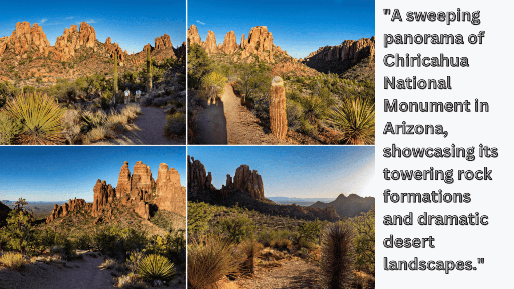
7.Chiricahua National Monument: Offbeat USA Gem in Arizona
Why it’s important to you
Chiricahua National Monument is important for its unique geological formations, known as “The Wonderland of Rocks,” where towering rock spires create a stunning and surreal landscape. It preserves the cultural heritage of the Chiricahua Apache and showcases diverse ecosystems, making it a vital area for both history and nature lovers. Its beauty and biodiversity make it a special destination in Arizona.
Chiricahua National Monument, located in southeastern Arizona, is a stunning wonderland of towering rock pinnacles and dramatic desert landscapes. Known as the “Wonderland of Rocks,” this unique area offers breathtaking views, scenic trails, and an abundance of wildlife. With its striking formations shaped by volcanic activity and erosion, Chiricahua provides a perfect destination for hikers, nature lovers, and anyone seeking to explore one of Arizona’s most fascinating natural treasures.
| Feature | Details |
|---|---|
| Location | Cochise County, Arizona, United States |
| Nearest City | Willcox, Arizona |
| Coordinates | 32°00′20″N 109°21′24″W |
| Area | 12,025 acres (48.66 km²) |
| Created | April 18, 1924 |
| Visitors | 60,577 (in 2018) |
Source: Wikipedia
Chiricahua National Monument, located in southeastern Arizona, is a hidden gem known for its stunning rock formations, diverse wildlife, and rich history. The park is home to the famous “sky islands” – mountain ranges that rise dramatically from the surrounding desert, creating a unique ecosystem of plants and animals. The monument is most famous for its striking rhyolite rock formations, which have been shaped over thousands of years into towering spires and balanced rocks, offering breathtaking views and hiking opportunities.
The park is open year-round, with the best time to visit being in spring and fall when the weather is mild and ideal for outdoor activities. There is an entrance fee, and visitors can explore a range of trails, from easy walks to more challenging hikes, all leading to scenic overlooks and fascinating geological formations. The monument is also great for birdwatching, with many species of birds calling it home, as well as for stargazing, thanks to its clear, dark skies.
Whether you’re hiking through the rock formations, exploring the fascinating history of the area, or simply enjoying the peaceful surroundings, Chiricahua National Monument offers a unique experience in the heart of the Arizona desert. Its stunning landscapes and quiet atmosphere make it an excellent destination for nature lovers and adventurers alike.
Top Activities:
- Hiking: Explore over 17 miles of trails, including the Heart of Rocks Loop, for breathtaking views of unique rock formations.
- Wildlife Watching: Spot diverse wildlife such as coatimundis, deer, and a variety of bird species.
- Scenic Drive: Take the 8-mile Bonita Canyon Drive to enjoy stunning vistas and access key trailheads.
- Photography: Capture the dramatic spires, balanced rocks, and vibrant desert landscapes.
- Historic Exploration: Visit the Faraway Ranch Historic District to learn about the park’s cultural and homesteading history.
- Camping: Stay overnight at the Bonita Canyon Campground to experience the monument’s tranquility under star-filled skies.
Best Time to Visit:
The best time to visit Chiricahua National Monument is in the spring (March to May) and fall (September to November), when temperatures are mild and ideal for hiking and exploring the park’s unique rock formations. These seasons also offer the chance to see wildflowers in bloom or vibrant autumn colors in the surrounding landscape.
8.Devils Kettle: Secret retreat in Minnesota
Devils Kettle in Minnesota is important for its geological mystery and natural beauty. This unique waterfall, located in Judge C.R. Magney State Park, features a split where half the Brule River flows into a visible plunge, while the other half disappears into a deep hole, the “kettle,” with no clear exit point. Its enigmatic nature and scenic surroundings make it a fascinating destination for nature enthusiasts and curious explorers.
Devils Kettle, nestled within Minnesota’s Judge C.R. Magney State Park, is a natural mystery that captivates visitors with its unique and enigmatic beauty. This intriguing waterfall splits in two, with one side flowing into the Brule River and the other vanishing into a deep, unexplained hole. Surrounded by lush forests and scenic trails, Devils Kettle offers a sense of wonder and adventure, making it a must-see destination for nature enthusiasts and curious travelers alike.
| Feature | Details |
|---|---|
| Location | Cook, Minnesota, United States |
| Coordinates | 47°51′4″N 90°3′30″W |
| Area | 4,643 acres (18.79 km²) |
| Elevation | 1,073 ft (327 m) |
| Established | 1957 |
Source: Wikipedia
Devils Kettle, located in Judge C. R. Magney State Park in northern Minnesota, is a mysterious and intriguing natural feature known for its unique waterfall. The Brule River splits into two branches, with one flowing into a large pool, while the other disappears into a hole in the rocks, forming the Devils Kettle. Despite years of research, the exact destination of the water from the kettle remains a mystery, adding an element of intrigue to this already captivating spot.
The park is open year-round, with summer being the best time to visit to fully experience the beauty of the waterfall and surrounding forest. There is no entrance fee to access the park, though parking and camping options are available for those wanting to stay longer. Visitors can explore a series of hiking trails, which lead to scenic viewpoints and provide opportunities for wildlife watching, fishing, and photography.
Whether you’re marveling at the strange phenomenon of the Devils Kettle, hiking along the river, or simply soaking in the peaceful surroundings, this unique spot offers a memorable experience. Its natural beauty and mysterious allure make it a must-visit destination for nature lovers and anyone intrigued by the wonders of the natural world.
Top Activities:
- Hiking: Embark on the Devil’s Kettle Trail, a moderately challenging hike that leads to the iconic waterfall. Along the way, enjoy scenic views of the Brule River and the surrounding forest.
- Waterfall Viewing: Witness the mysterious Devil’s Kettle waterfall, where one side of the waterfall vanishes into a deep hole with no known exit, sparking curiosity and wonder.
- Photography: Capture the beauty of the cascading waterfalls, lush greenery, and dramatic landscapes. The Devil’s Kettle itself is a unique subject for creative photography.
- Wildlife Watching: Spot native wildlife, including deer, foxes, and a variety of birds, as you explore the park’s tranquil trails and riverbanks.
- Picnicking: Relax at one of the park’s designated picnic areas, enjoying the serene surroundings and the sound of rushing water from the Brule River.
- Fishing: Cast a line in the Brule River, which is known for its trout population, offering a peaceful fishing experience in a stunning natural setting.
- Fall Foliage Viewing: Visit in autumn to see the vibrant fall colors that transform the park’s forests into a stunning mosaic of reds, oranges, and yellows.
- Snowshoeing and Winter Hiking: In colder months, explore the snow-covered trails, offering a serene and picturesque view of the park’s winter wonderland.
- Educational Exploration: Learn about the geological mystery of Devil’s Kettle and the unique features of the park at the visitor center or through interpretive signage along the trails.
Best Time to Visit:
The best time to visit Devil’s Kettle in Judge C.R. Magney State Park is from late spring to early fall (May to October), when the weather is mild and the trails are easily accessible. For vibrant fall foliage and cooler temperatures, September and October are particularly stunning.